Rouen Vallée de Seine Airport
Daylight today(Oct 16, 2026, local time)
About 10h 47m of daylight. Civil twilight (dawn/dusk) approximates the FAA definition of night for logging and currency. Times are computed and approximate — verify with official sources.
About Rouen Vallée de Seine Airport
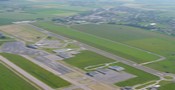
Rouen Airport or Aéroport de Rouen - Vallée de Seine is an airport located in Boos and 10 km southeast of Rouen, both communes of the Seine-Maritime département in the Normandy région of France.
Summary from Wikipedia, photo via Wikimedia Commons, licensed under CC BY-SA.
Live weather
LFOPNOTAMs
LFOPReference only — not an official briefing. Always obtain a certified briefing (e.g. 1800wxbrief.com / your AIS) before flight.
NOTAM data via the FAA NOTAM system.
Live departures & arrivals
Flight data by AeroDataBox. Times are estimates — not for navigation; confirm with the airline.
Where you can fly from here
Current scheduled routes & daily frequency by AeroDataBox. Approximate — confirm bookable schedules with the airline.
Live traffic nearby
Aircraft currently within ~40 nm, from live ADS-B. Positions are approximately real-time — not for navigation.
Live ADS-B by adsb.lol & the OpenSky Network. Not for navigation.
Map
Runway centrelines, navaids and overlapping airspace. Tiles © OpenStreetMap contributors. Reference only — not for navigation.
Runways (2)
| Runway | Length | Width | Surface | Lighting | Status |
|---|---|---|---|---|---|
| 04 / 22 | 5,577 ft / 1,700 m | 148 ft | Asp | Lighted | Open |
| 05 / 23 | 2,952 ft / 900 m | 262 ft | Grass | Unlit | Open |
Radio frequencies (3)
| Type | Description | Frequency |
|---|---|---|
| APP | ROUEN APP | 118.575 MHz |
| ATIS | ATIS | 120.730 MHz |
| TWR | ROUEN TWR | 120.200 MHz |
Services & operations
From the airport’s official website — details may change, so confirm with the airport. Official site
Airspace in this area(14)
| Name | Class | Type | Floor | Ceiling |
|---|---|---|---|---|
| TMA PARIS 7 | Class A | TMA | FL065 | FL085 |
| CTR ROUEN | Class D | CTR | GND | 2000 ft MSL |
| TMA LILLE 14 (MON-FRI) | Class D | TMA | 2000 ft MSL | 3500 ft MSL |
| LTA FRANCE 1 | Class D | Type 34 | FL115 | FL195 |
| TMA LILLE 16 | Class E | TMA | 3500 ft MSL | FL065 |
| TMA LILLE 15 | Class E | TMA | 2000 ft MSL | 3500 ft MSL |
| TMA PARIS 1 | Class E | TMA | 3500 ft MSL | FL115 |
| LF-R605A ROUEN EST | Special use | Gliding sector | 2000 ft MSL | 3500 ft MSL |
| FIR LFFF | Special use | FIR | GND | FL195 |
| LF-R605B ROUEN OUEST | Special use | Gliding sector | 2000 ft MSL | 3500 ft MSL |
| SIV LILLE 6.1 | Special use | Type 33 | GND | FL115 |
| SIV LILLE 6.2 | Special use | Type 33 | GND | FL085 |
| SIV LILLE 6.3 | Special use | Type 33 | GND | FL065 |
| SIV PARIS NORD | Special use | Type 33 | GND | FL195 |
Approximate bounding-box match from OpenAIP · all France airspace. Reference only — consult official charts for exact boundaries and status.
VFR reporting points nearby
| Point | Distance | Bearing | Reporting |
|---|---|---|---|
| S | 4.9 nm | 152° | Compulsory |
| N | 6.4 nm | 348° | Compulsory |
| E | 7.2 nm | 103° | Compulsory |
| SB | 7.2 nm | 193° | Compulsory |
| W | 8.3 nm | 237° | Compulsory |
| AC | 11.3 nm | 290° | On request |
| NW | 13.1 nm | 318° | On request |
Named VFR reporting points within ~20 nm; distance and bearing are from the airport reference point. Data via OpenAIP. Reference only — check the current VAC/AIP for procedures and whether a report is required.
Tall obstacles nearby
| Obstacle | Height AGL | Top (MSL) | Lit |
|---|---|---|---|
| TDF - Les Essarts | 741 ft | 371 ft | — |
| TDF Rouen - Bonsecours | 397 ft | 449 ft | — |
| Obstacle | 282 ft | 3 ft | — |
| Obstacle | 282 ft | 3 ft | — |
| Obstacle | 230 ft | 512 ft | — |
| Obstacle | 230 ft | 505 ft | — |
| Obstacle | — | 420 ft | — |
| Obstacle | — | 515 ft | — |
Tallest obstacles within ~10 nm. Data via OpenAIP. Reference only — consult official charts.
Nearby airports
Great-circle distance and true bearing from Rouen Vallée de Seine Airport.
Frequently asked questions
What is the ICAO code for Rouen Vallée de Seine Airport?
The ICAO code for Rouen Vallée de Seine Airport is LFOP, and its IATA code is URO.
Where is Rouen Vallée de Seine Airport located?
Rouen Vallée de Seine Airport is medium airport located in Boos, France, at an elevation of 512 ft (156 m).
How many runways does Rouen Vallée de Seine Airport have?
Rouen Vallée de Seine Airport has 2 runways, the longest being 5,577 ft / 1,700 m.
What time zone is Rouen Vallée de Seine Airport in?
Rouen Vallée de Seine Airport is in the Europe/Paris time zone (UTC+02:00).
What is the magnetic variation at Rouen Vallée de Seine Airport?
The magnetic variation (declination) at Rouen Vallée de Seine Airport is approximately 1.7° E, per the World Magnetic Model. Variation changes slowly over time — always use the current value charted for navigation.
What airports are near Rouen Vallée de Seine Airport?
The nearest airport to Rouen Vallée de Seine Airport is Val-de-Reuil Ultralight Airfield (FR-0436), about 6.5 nm to the sse, followed by Saint-Cyr-la-Campagne Airfield and Cesseville Ferme des Moulins Private Airfield.
Is the information on this page suitable for flight planning?
No. Rouen Vallée de Seine Airport data here is for reference and training only — not for navigation. Always consult official sources and current charts before any flight.