Bach Mai Heliport
Daylight today(Oct 13, 2026, local time)
About 11h 44m of daylight. Civil twilight (dawn/dusk) approximates the FAA definition of night for logging and currency. Times are computed and approximate — verify with official sources.
About Bach Mai Heliport
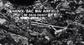
Bach Mai Airfield is a disused military airport in Thanh Xuân district, Hanoi, Vietnam, located along modern-day Le Trong Tan street. It was constructed by the French in 1917 and used by French forces until 1954; along with Gia Lam Airbase, it was one of the major logistics bases supporting French operations at Dien Bien Phu. After 1954, it was used by the Vietnamese People's Air Force and served as their air defense command and control center during the Second Indochina War, playing a part in the Cambodian–Vietnamese War as well. It is now the site of the Vietnam People's Air Force Museum, where a number of period military aircraft are on display.
Summary from Wikipedia, photo via Wikimedia Commons, licensed under CC BY-SA.
Live traffic nearby
Aircraft currently within ~40 nm, from live ADS-B. Positions are approximately real-time — not for navigation.
Live ADS-B by adsb.lol & the OpenSky Network. Not for navigation.
Map
Runway centrelines, navaids and overlapping airspace. Tiles © OpenStreetMap contributors. Reference only — not for navigation.
Runways (0)
No runway data recorded for this airport.
Nearby airports
Great-circle distance and true bearing from Bach Mai Heliport.
Frequently asked questions
Where is Bach Mai Heliport located?
Bach Mai Heliport is heliport located in Hanoi (Thanh Xuan), Vietnam.
What time zone is Bach Mai Heliport in?
Bach Mai Heliport is in the Asia/Bangkok time zone (UTC+07:00).
What is the magnetic variation at Bach Mai Heliport?
The magnetic variation (declination) at Bach Mai Heliport is approximately 1.7° W, per the World Magnetic Model. Variation changes slowly over time — always use the current value charted for navigation.
What airports are near Bach Mai Heliport?
The nearest airport to Bach Mai Heliport is Gia Lam Air Base (VVGL), about 4 nm to the ne, followed by Noi Bai International Airport and Hoa Lac Airfield.
Is the information on this page suitable for flight planning?
No. Bach Mai Heliport data here is for reference and training only — not for navigation. Always consult official sources and current charts before any flight.