Fürstenfeldbruck Air Base
Daylight today(Oct 14, 2026, local time)
About 10h 57m of daylight. Civil twilight (dawn/dusk) approximates the FAA definition of night for logging and currency. Times are computed and approximate — verify with official sources.
About Fürstenfeldbruck Air Base
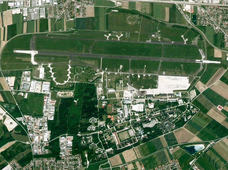
Fürstenfeldbruck Air Base (German: "Fliegerhorst Fürstenfeldbruck" or "Flugplatz Fürstenfeldbruck") is a former German Air Force airfield near the town of Fürstenfeldbruck in Bavaria, near Munich, Germany. Fürstenfeldbruck became famous first as the main training base for the German Luftwaffe during World War II, then as the site of the Munich massacre of nine Israeli athletes and coaches (two were killed earlier) and one German police officer at the 1972 Summer Olympics. Military flight operations ceased in 2003, a small civil flight operation ended in 2015. The adjacent barracks are still used by the German Air Force Officer Training School, which is to be relocated to Roth. In the eastern part of the former air base, the BMW Driving Academy Maisach was established.
Summary from Wikipedia, photo via Wikimedia Commons, licensed under CC BY-SA.
Live traffic nearby
Aircraft currently within ~40 nm, from live ADS-B. Positions are approximately real-time — not for navigation.
Live ADS-B by adsb.lol & the OpenSky Network. Not for navigation.
Map
Runway centrelines, navaids and overlapping airspace. Tiles © OpenStreetMap contributors. Reference only — not for navigation.
Runways (1)
| Runway | Length | Width | Surface | Lighting | Status |
|---|---|---|---|---|---|
| 09 / 27 | 9,003 ft / 2,744 m | 151 ft | Con | Unlit | Open |
Radio frequencies (2)
| Type | Description | Frequency |
|---|---|---|
| AAS | MUNCHEN INFO | 126.950 MHz |
| INFO | INFO | 123.700 MHz |
Airspace in this area(9)
| Name | Class | Type | Floor | Ceiling |
|---|---|---|---|---|
| MUENCHEN | Class C | TMA | FL085 | FL100 |
| MUENCHEN | Class C | TMA | 5500 ft MSL | FL100 |
| MUENCHEN | Class C | TMA | 3500 ft MSL | FL100 |
| MUENCHEN | Class C | TMA | 4500 ft MSL | FL100 |
| MUENCHEN | Class C | TMA | FL065 | FL100 |
| AREA | Class E | Controlled | 2500 ft GND | FL100 |
| MUENCHEN | Class E | Controlled | 1000 ft GND | 2500 ft GND |
| FIS LANGEN | Special use | Type 33 | GND | FL100 |
| EDMM | Special use | FIR | GND | FL245 |
Approximate bounding-box match from OpenAIP · all Germany airspace. Reference only — consult official charts for exact boundaries and status.
VFR reporting points nearby
| Point | Distance | Bearing | Reporting |
|---|---|---|---|
| WHISKEY | 8.7 nm | 213° | Compulsory |
| ECHO2 | 9.4 nm | 164° | Compulsory |
| ECHO | 12.6 nm | 260° | Compulsory |
| SIERRA1 | 13.8 nm | 325° | Compulsory |
| SIERRA2 | 17.3 nm | 314° | On request |
| OSCAR2 | 18.5 nm | 324° | On request |
| OSCAR1 | 21.7 nm | 329° | Compulsory |
| NOVEMBER2 | 21.9 nm | 320° | On request |
| WHISKEY2 | 22.1 nm | 306° | On request |
| LIMA | 23.1 nm | 318° | Compulsory |
Named VFR reporting points within ~20 nm; distance and bearing are from the airport reference point. Data via OpenAIP. Reference only — check the current VAC/AIP for procedures and whether a report is required.
Tall obstacles nearby
| Obstacle | Height AGL | Top (MSL) | Lit |
|---|---|---|---|
| Obstacle | 679 ft | 1,654 ft | — |
| Windkraftanlage Mammendorf | 656 ft | 1,831 ft | — |
| Windkraftanlage Malching | 656 ft | 1,729 ft | — |
| Windrad 5 | 463 ft | 1,736 ft | — |
| Obstacle | 463 ft | 1,795 ft | — |
| Obstacle | 463 ft | 1,765 ft | — |
| Obstacle | 463 ft | 1,772 ft | — |
| Windrad 4 | 463 ft | 1,745 ft | — |
Tallest obstacles within ~10 nm. Data via OpenAIP. Reference only — consult official charts.
Frequently asked questions
Where is Fürstenfeldbruck Air Base located?
Fürstenfeldbruck Air Base is closed located in Fürstenfeldbruck, Germany, at an elevation of 1,703 ft (519 m).
How many runways does Fürstenfeldbruck Air Base have?
Fürstenfeldbruck Air Base has 1 runway, the longest being 9,003 ft / 2,744 m.
Is the information on this page suitable for flight planning?
No. Fürstenfeldbruck Air Base data here is for reference and training only — not for navigation. Always consult official sources and current charts before any flight.